
📊 Data story
Dig straight down from any US state and you hit… the ocean
Every state except one comes out in the southern Indian Ocean. So we worked out how far you’d have to swim to reach land from the end of each state’s tunnel.
- Lands on land!
- Under 400 km
- 400–800 km
- 800–1,200 km
- 1,200–1,600 km
- 1,600 km or more
Swim distance from the exact opposite of the middle of each state to the nearest land. Tap a state to dig from it. Download the map image.
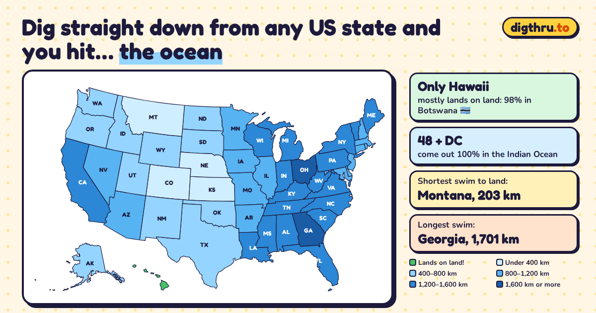
- 48 + DCstates come out 100% in the Indian Ocean (all 48 in the lower 48)
- 1state lands on land: Hawaii, 98.3% in Botswana
- 203 kmMontana has the shortest swim, to the Kerguelen Islands
- 1,701 kmGeorgia has the longest swim, to Western Australia
The only state that hits dry land
Hawaii is the one exception. Flip the islands through the center of the Earth and about 98.3% of them land in Botswana, in the Kalahari, with the rest just over the border in Namibia. A tunnel from Honolulu would come out about 70 km northeast of the town of Ghanzi.
Alaska is the only other state that touches land at all: about 2.1% of it flips onto Antarctica. The rest comes out in the icy waters of the Southern and Indian Oceans.
Where everybody else ends up
The other 48 states and Washington, DC all come out in the southern Indian Ocean, a huge empty stretch of sea southwest of Australia. The East Coast flips toward Western Australia. The middle of the country lands near some of the loneliest islands on Earth, the French Kerguelen, Saint-Paul and Amsterdam islands, where the only people are a few dozen scientists and staff at research stations.
That gives the Rocky Mountain states the shortest swims. Dig from the middle of Montana and you’d surface about 203 km from the Kerguelen Islands. From Colorado, tiny Saint-Paul Island is about 270 km away. The Southeast gets the worst deal: Georgia’s tunnel ends about 1,701 km from the coast of Western Australia.
Find out where your own tunnel comes out →Every state, from shortest swim to longest
| State | Comes out in | Nearest land | Swim |
|---|---|---|---|
| Hawaii | 🌍 Botswana (98.3%) | You’re on it! (Botswana) | 0 km |
| Montana | 🌊 Indian Ocean | Kerguelen Islands* | 203 km |
| Colorado | 🌊 Indian Ocean | Saint-Paul Island* | 267 km |
| Kansas | 🌊 Indian Ocean | Saint-Paul Island* | 355 km |
| Nebraska | 🌊 Indian Ocean | Saint-Paul Island* | 385 km |
| New Mexico | 🌊 Indian Ocean | Amsterdam Island* | 499 km |
| Oklahoma | 🌊 Indian Ocean | Amsterdam Island* | 506 km |
| Idaho | 🌊 Indian Ocean | Kerguelen Islands* | 536 km |
| Alaska | 🌊 Indian Ocean (65%) | Antarctica | 556 km |
| Washington | 🌊 Indian Ocean | Crozet Islands* | 594 km |
| Wyoming | 🌊 Indian Ocean | Saint-Paul Island* | 637 km |
| Oregon | 🌊 Indian Ocean | Crozet Islands* | 654 km |
| South Dakota | 🌊 Indian Ocean | Saint-Paul Island* | 660 km |
| North Dakota | 🌊 Indian Ocean | Kerguelen Islands* | 691 km |
| Texas | 🌊 Indian Ocean | Amsterdam Island* | 763 km |
| Utah | 🌊 Indian Ocean | Saint-Paul Island* | 795 km |
| Iowa | 🌊 Indian Ocean | Saint-Paul Island* | 844 km |
| Missouri | 🌊 Indian Ocean | Saint-Paul Island* | 869 km |
| Arizona | 🌊 Indian Ocean | Amsterdam Island* | 913 km |
| Arkansas | 🌊 Indian Ocean | Amsterdam Island* | 952 km |
| Rhode Island | 🌊 Indian Ocean | Western Australia | 1,004 km |
| Connecticut | 🌊 Indian Ocean | Western Australia | 1,059 km |
| Massachusetts | 🌊 Indian Ocean | Western Australia | 1,067 km |
| Minnesota | 🌊 Indian Ocean | Saint-Paul Island* | 1,071 km |
| Delaware | 🌊 Indian Ocean | Western Australia | 1,075 km |
| New Jersey | 🌊 Indian Ocean | Western Australia | 1,079 km |
| Nevada | 🌊 Indian Ocean | Kerguelen Islands* | 1,115 km |
| Illinois | 🌊 Indian Ocean | Saint-Paul Island* | 1,147 km |
| Maryland | 🌊 Indian Ocean | Western Australia | 1,176 km |
| New Hampshire | 🌊 Indian Ocean | Western Australia | 1,178 km |
| District of Columbia | 🌊 Indian Ocean | Western Australia | 1,191 km |
| Louisiana | 🌊 Indian Ocean | Amsterdam Island* | 1,219 km |
| Wisconsin | 🌊 Indian Ocean | Saint-Paul Island* | 1,223 km |
| California | 🌊 Indian Ocean | Crozet Islands* | 1,248 km |
| Maine | 🌊 Indian Ocean | Western Australia | 1,248 km |
| Vermont | 🌊 Indian Ocean | Western Australia | 1,266 km |
| Mississippi | 🌊 Indian Ocean | Amsterdam Island* | 1,288 km |
| Virginia | 🌊 Indian Ocean | Western Australia | 1,303 km |
| North Carolina | 🌊 Indian Ocean | Western Australia | 1,317 km |
| New York | 🌊 Indian Ocean | Western Australia | 1,325 km |
| Pennsylvania | 🌊 Indian Ocean | Western Australia | 1,346 km |
| Indiana | 🌊 Indian Ocean | Saint-Paul Island* | 1,395 km |
| Tennessee | 🌊 Indian Ocean | Amsterdam Island* | 1,445 km |
| South Carolina | 🌊 Indian Ocean | Western Australia | 1,461 km |
| West Virginia | 🌊 Indian Ocean | Western Australia | 1,479 km |
| Kentucky | 🌊 Indian Ocean | Saint-Paul Island* | 1,504 km |
| Alabama | 🌊 Indian Ocean | Amsterdam Island* | 1,521 km |
| Florida | 🌊 Indian Ocean | Western Australia | 1,556 km |
| Michigan | 🌊 Indian Ocean | Saint-Paul Island* | 1,580 km |
| Ohio | 🌊 Indian Ocean | Saint-Paul Island* | 1,692 km |
| Georgia | 🌊 Indian Ocean | Western Australia | 1,701 km |
* Part of the French Southern and Antarctic Lands, an overseas territory of France with no permanent residents.
How we worked it out
For each state we took a point near its middle (the center of its largest piece of land), found the exact opposite point on the globe, and measured the great-circle distance from there to the nearest coastline in Natural Earth’s most detailed country map, which includes small islands. The “comes out in” column comes from flipping the state’s whole area, as on each state page. Distances are approximate: a tunnel from a different spot in the same state can land hundreds of kilometers away.
Sources
- Natural Earth (1:10m country and coastline data)
- US Census Bureau state boundaries, via us-atlas
- CIA World Factbook: French Southern and Antarctic Lands